
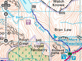
 Grey Mare's Tail is a 200ft waterfall, the fifth highest in Britain, and in full flood a very impressive site. This short walk takes us past the falls and up to Loch Skeen, one of the wilder lochs in the Scottish Borders.
Ascent: 900ft
Length: 2 miles
Last Walked: Autumn 2010
We start at the Grey Mare's Tail visitor centre car park, on the A 708 (the Moffat to Selkirk road)
![]() Two paths leave the car park heading towards the water fall. Take the right-hand path, which leads to a bridge over the Tail Burn. After crossing the bridge follow the path as it zig-zags before turning left to climb up the side of the valley. The path then
Two paths leave the car park heading towards the water fall. Take the right-hand path, which leads to a bridge over the Tail Burn. After crossing the bridge follow the path as it zig-zags before turning left to climb up the side of the valley. The path then ![]() heads up the valley towards the waterfall, with the burn to the left (down a fairly steep slope).
heads up the valley towards the waterfall, with the burn to the left (down a fairly steep slope).
Follow this path as it climbs up to the falls and then passes above them. The path then follows the burn all the way to Loch Skeen.