
 This walk takes us up the very fine north-west ridge of Great Gable, and up to one of the finest viewpoints in the entire Lake District at the summit of the fell. On a good day this is a very busy fell, but our route manages to avoid the crowds for at least some of the route, most especially on the descent, where we follow the valley route from Sty Head to Wasdale instead of the very busy path further up the fellside.
Ascent: 2,700ft
Length: 5.6 miles
Map: SW
Last Walked: 17 October 2009
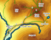
We start from the village green car park at Wasdale Head.
Our route on takes us straight over the summit, heading south-east from the cairn onto the path that runs down to Sty Head. The line of cairns takes us a little to the north of the right of way marked on OS maps, and provides great views towards Styhead Tarn. A clear path soon develops, which takes us to the left of Dry Tarn, hidden just off the path, and then down to Sty Head.
![]()
![]()
![]()
![]()
A number of very busy paths meet at Sty Head, but we are going to ignore all of them. Our path down Great Gable passes to the side of a box of rescue equipment and reaches a crossroads. Turn right at this junction, but then after a very short distance turn left onto a very minor path (looking more like a swamp) at the start. This path quickly develops into a very clear path that runs down a small gully, and then zig-zags its way down into the upper reaches of Wasdale. A number of different paths run down the valley - the clearest runs around the upper slopes, crosses one beck and then runs down the valley towards a junction between Lingmell Beck and Piers Gill. Cross from the left to right bank of Lingmell Beck, and then follow the increasingly clear path as it runs back down the valley, rejoining our original route at the bridge over Gable Beck. After that we retrace our steps back to the car park.
![]()
![]()