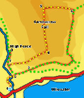
 This walk combines an ascent of Gowbarrow Fell with a visit to Aira Force. This is one of the minor fells, at just over 1,500ft, but its isolated position away from surrounding high ground makes it a very good viewpoint, with clear views west towards Hellvelyn and east to the Pennines from the summit, and fantastic views of Ullswater from the southern edge of the summit plateau.
Aira Force itself is a series of falls in a managed landscape, with a series of viewing points provided, including two bridges that cross the beck.
Ascent: 1,370ft/ 400m
Length: 4.4 miles/ 7km
Map: Explorer 005 English Lakes North East
Last Walked: 18 June 2005
We start from the National Trust car park for Aira Force, just to the east of the road to Dockray.
1: NY 400 200
Leave the car park on the major tourist path that leads north towards Aira Force. Follow it as it curves around to the right through the trees that line Aira Beck.
2: NY 400 202
At the end of this curve, a path leaves to the right, crossing over a bridge over Aira Beck. Take this path and cross the beck. A second major tourist path leads north from the bridge, heading up the eastern bank of the beck. The first part of this path runs close to edge of the woods, curving around to the left. When the path begins to straighten out and leave the edge of the woods, turn right onto a

smaller path that heads north east, running close to the edge of the trees. After a short distance this path reaches the north eastern edge of the wood, and joins another path at a t-junction. Turn right onto this path and follow it as it runs east, along the southern flank of Gowbarrow Fell, with the open fell to the left and fields to the right.
3: NY 403 204
After about 600 feet this path splits in two. The right hand branch continues to run east along the edge of the fields, while the left hand branch begins to climb up the slopes of Gowbarrow Fell. Take the left hand branch.
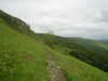 We will follow this path for the next mile and a half as it climbs up and around the southern and eastern flanks of Gowbarrow Fell. At the south eastern corner of the fell, the path passes the memorial seat above Yew Crag, a famous viewpoint, before turning north to continue the climb.
4: NY 414 217
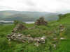 After a prolonged period where our path climbs almost continuously as it works its way around the eastern flank of the fell, it begins to drop down towards a stone wall, and the ruins of a shooting lodge. This is the point at which we leave this path, and begin the final assualt on the summit.
There are two alternative routes here. The easiest route is to follow the line of the wall as it climbs up towards the ridge between Gowbarrow Fell and Great Meldrum. Near the top of the ridge, another wall runs west across the top of Gowbarrow Fell. Turn left and follow the line of this wall for as long as it keeps climbing. Where the wall begins to drop down the western side of the fell, turn left and head up towards the trig point on the summit of Gowbarrow Fell.
The alternative route is rather more direct. At the shooting lodge turn left and scramble up the slope towards the highest point on the skyline, and keep on going until reaching the summit. This is the method that I used.
5: NY 407 218
A reasonably clear path leaves the highest part of the summit heading south towards Ullswater. Follow this path across the summit plateau, to the top of the slope overlooking the lake.
6: NY 408 209
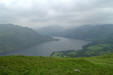
The southern edge of the summit plateau provides the best views over Ullswater, and as a result a clear path runs west to east along the top of the southern slopes of the fell. Turn right and follow this path as is drops down the south western flank of the fell, heading back towards the valley of Aira Beck. This is an easy safe path all the way down, although the shape of the fell does mean that there are some alarming moments towards the top where in the middle distance the path appears to drop off the edge of the fell - in each case as one gets closer to the apparent drop more of the slope comes into sight.
7: NY 400 205

Towards the bottom of the slope the path splits a number of times, but each of these alternative routes soon reach the major tourist path along the eastern bank of Aira Beck. Turn right and follow the tourist path through the trees up to Aira Force.
8: NY 400 209
From Aira Force, paths run down both sides of the beck, returning to the car park. We chose the eastern path, which runs between some impressive trees, and returns to the car park across the bridge we crossed back at step two.
