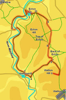
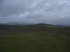
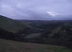
 This walk takes us around the northern end of the steep sided section of the Manifold Valley, visiting the summit of Wetton Hill at its southern end before returning along the eastern slopes of Ecton Hill. In this short circuit we pass through three distinct types of scenery - first the steep sided valley of the Manifold, then the open grassy slopes of Wetton Hill and finally the more typical White Peak scene on Ecton Hill, with sweeping views away to the north-east.
Ascent: 1,400ft
Length: 5.5 miles
Map:  OL 24 White Peak Area
Last Walked: 31 December 2012
We start from a small car park on the minor road that runs alongside the Maniford just to the south of Ecton village. This can be reached from the B 5054 west of Hartington. If coming from the east turn left just as you reach Hulme End (just before the bridge over the Manifold). Take the next right then follow this road as it runs alongside the river. Soon after passing a side road that crosses the river look for a layby at the foot of an abandoned quarry.
If approaching from the west take the right right turn after Warslow, then turn right again. This brings you to the bridge we ignored coming from the east. Cross the bridge and turn right to reach the layby.
1: SK 097 582
Turn right out of the layby and head north up the valley (with the river to the left). This brings us past a side-road that climbs up into Ecton, and then approaches the bridge over the river. At this point the Manifold Way comes into sight on the left, following the course of an old railway. Turn left onto the Maniford Way and follow it south. The track soon crosses the river and continues along with the water to the left.
2: SK 091 577
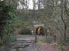
This stretch of path eventually brings us to a road facing a stretch of tunnel (originally the rail tunnel, now used by a road). Turn left onto the road in front of the tunnel and follow it as it crosses the river. On the far side of the river turn right onto a well made track and follow it south, with the river to the right.
3: SK 095 562

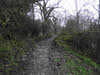
This good quality track follows the line of the river for about a mile and a half, sometimes climbing some way above the water. Eventually it emerges onto the
end of a small lane. Turn right onto this lane and follow it towards a bridge over theManiford. Just before we reach the bridge turn left into a farmyard/ tearoom. Follow the footpath signs in the yard, which bring us to the fields behind the buildings, where a path climbs quite steeply up a grassy slope, through a cutting and onto a ridge.
4: SK 097 560
At the top of the ridge turn sharply left (following a footpath signpost). The path drops down into a valley between this ridge and Wetton Hill (seen straight ahead when we first reached the top of the hill). At the bottom of this slope follow the path that heads north-east up the valley between Wetton Hill on the right and an equally steep slope on the left.
5: SK 104 566
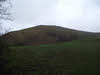
We follow this path to the top of the valley, passing through an area of open grassland more typical of wilder landscapes further north. The path emerges onto a minor road, but before we reach the road we will take a diversion to the top of Wetton Hill. Turn right onto a clear grassy path that climbs up to the right of the stone wall at the edge of the open grassland. Follow this path as it curves around to the right following the wall, eventually reaching a col between Wetton Hill and the high ground to the left. At this point turn right and head up the hill to reach the summit, with its wide sweeping views (there is no path at this stage).
6: SK 105 562
Retrace your steps from the summit - down the slope and then turn left to follow the wall back down into the valley.
7: SK 104 566
Once back in the valley turn right onto a lane. Follow this lane as it heads north, then turns sharply to the left and climbs, before turning right again to run north along the eastern flank of Ecton Hill
8: SK 103 572
This road brings us to a Y-junction. Take the right-hand lane, which heads slightly downhill before leveling out and continuing on to the north.
9: SK 103 580
Follow this lane until it turns sharply to the right. At this point a track continues on to the north, curving gently to the left as it climbs around the northern ridge of the hill. Follow this track to the top of the ridge, where it rather fades away.
10: SK 099 583
At the top of the ridge our track reaches an isolated stone building. Our path passes to the left of this building and then drops rather steeply down the slope towards Ecton. After a bit the path begins to zigzag down the slope - aim for the bottom-right hand corner of the field. At this corner cross a stile and then turn right and head through an arch that brings us to the end of the lane at Ecton. Follow this lane past some interesting houses and back to the road down the Manifold Valley. Turn left onto the main road and return to the car park.
