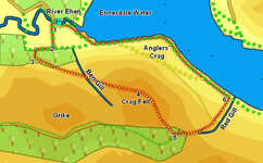
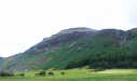
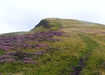
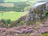
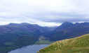
 This short walk takes us to the top of Crag Fell, the fell that dominates the western end of Ennerdale Water. This route takes us up the gentle western slopes of the fell, before leaving the clear footpaths to drop down to the lake to the east of Anglers' Crag. The summit of Crag Fell provides one of the best views into the small farmed area of Ennerdale at the head of the lake, while the return trip along the lake shore includes a nice little scramble around the base of Anglers' Crag.
Ascent: 1,570ft
Length: 3.9 miles
Map: The English Lakes - North Western Area (OS Explorer Map Active)
Last Walked: 13 August 2009
We start from the Forestry Commission car park at Broadmoor, best approached along the road that passes the school in Ennerdale Bridge.
1: NY 085 153
Leave the car park via the motor entrance. This brings us to a cross-roads - left goes to the lake, right crosses the Ehen but we head straight ahead along a track that takes us straight towards the fell side and Crag Farm. This track passes to the right of the farm, and reaches a T-junction with a track that runs parallel to the fells.
2: NY 084 150
Turn right onto this track. After a short distance a clear path heads off to the left, climbing steeply up the fell side. Take this path. Ignore the grassy platform reached after a short distance and continue on up until this path reaches a good footpath cutting diagonally across the hillside.
3: NY 082 149
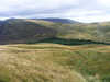
Turn left onto this path and follow it as it climbs all the way up to the top of the fell, at first running through woodland, then around the top of the dramatic gorge cut by Ben Gill and finally up the open fell above the crags.
4: NY 097 143
Follow the clear path that leaves the summit heading south-east towards a small plantation that reaches into the gap between Crag Fell and the western end of
Caw Fell.
5: NY 101 137
This path runs down into the trees and joins a track (the old miner's road, now a forestry track). Turn left onto this track and follow it out of the woods. At this point things become a bit less clear on the ground. The track leads towards an elaborate double gate. Pass through this gate, and then turn right and follow the line of the fence until it reaches a stone wall. Turn left and follow the line of this wall down into the bottom corner of the field. Cross the stone wall here and follow the path that runs down alongside Red Back down to the side of Ennerdale Water (an alternative path runs across the front of Crag Fell heading for Anglers' Crag, but this route is now not very clear on the ground)
6: NY 109 143
At the lake shore turn left and follow the path as it runs around the base of Anglers' Crag and around to the point where the River Ehen leaves the lake. Stay on the near side of the river and follow the path downstream until it branches - take the right hand branch and follow it back to the car park.
