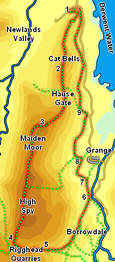
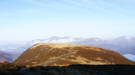
 This walk takes us onto the popular tourist destination of Cat Bells, but then continues on to the significantly higher Maiden Moor and High Spy, before returning along the edge of Borrowdale.
Ascent: 2,800ft
Length: 9 miles
Map: The English Lakes - North Western Area (OS Explorer Map Active)
Last Walked: Autumn 2009
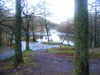
We start from the small car park at Gutherscale, at the northern tip of Cat Bells. Be warned this is a small but very busy car park, so arrive early!
1: NY 245 211
 A footpath leaves the car park at its eastern end (towards Derwent Water). Take this path, and follow it as it climbs up across the northern slopes of Cat Bells. This path crosses the rocky spine of the fell, and then turns sharply to the right
  and climbs up towards the ridge line.
Once on the ridge the route onwards is clear all the way to the top of Cat Bells. Two rocky patches have to be negotiated before the summit is reached, but the path is otherwise easy.
2: NY 243 198
From the summit continue on south along the ridge down to Hause Gate, continue on across this pass and follow the path as it climbs up onto
Maiden Moor 3: NY 238 182
The main path across Maiden Moor doesn't actually visit the summit of the fell, instead passing some way to its left. We will correct this. At first the main path climbs up the middle
of a sloping plateau. As it begins to level out a minor path branches off to the right, heading towards the western edge of the fell (passing through a shallow valley). This path brings us to a second major path that runs along the edge of the fell. Turn left onto this path and follow it up to the summit of Maiden Moor. We then continue on along the same path onto the summit of High Spy, and then down to Wilson's Bield.
4: NY 231 154

This path brings us down towards a bowl in the hills between
Dale Head and High Scawdel, and containing
Dalehead Tarn. We don't want to follow the path down as far as the tarn. Instead, follow the path until it comes level with the lowest point on the

ridge that runs south from High Spy onto High Scawdel. At this point turn left and cross this marshy ground. At the opposite side of this wet patch we reach a fence. Cross this fence and follow the path as it brings us into Rigghead Quarries, where there are some impressively elaborate ruins. Follow the path as it winds its way through the quarries and down the valley towards Tongue Gill.
5: NY 238 153
Cross the gill at the first opportunity, close to where the path first reaches the stream. Our path runs down the left-hand side of the stream, then curves away to the left and runs north, between the eastern slopes of High Spy and
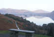
Castle Crag. Follow this path all the way down to the River Derwent
6: NY 250 165
Just before reaching the Derwent our path crosses from the left to right banks of Broadslack Gill. At the river turn left, cross back across the gill, and follow the path alongside the river. After a short distance it turns into more of a track, and heads a little away from the river.
7: NY 249 170
This track then joins a tarmac road that leads up to Hollows Farm. Turn left onto this road and follow it towards the farm. At the farm the track curves around to the right, and heads north.
8: NY 248 175
We follow this track north past Swanesty How, until we reach the edge of a small wood. Here we turn left, following the footpath as it climbs up along the side of the trees, then turn right at the upper edge of the trees, and follow the path as it runs north.
In theory this path runs along the base of the eastern slopes of Maiden Moor, but the clearest path now runs a little further up the hill, heading north with the steep slopes to the left, and the valley floor of Borrowdale to the right.
9: NY 248 186
We follow this path across the fell side until it joins a track running right-to-left up the hillside, with another small wood behind it. Turn left onto this track, then right at the end of the wood. We are now back on the lower slopes of Cat Bells. Follow this well constructed path as it runs north, now with Derwent Water to the right. Our path briefly comes down to the road just above Brandelhow Bay, then after another mile joins the road close to the northern tip of Cat Bells. Follow this road for a short distance, then turn left onto the road that leads back to the car park.
