
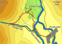
 This is one of the best short walks in the Lake District. In its three miles we walk alongside the River Derwent, climb through woodlands, take one of the most unusual of paths as it clambers up an old spoil heap, visit a perfect miniature summit with views of Borrowdale and Derwent Water and return across the open fellside at the foot of High Spy.
Ascent: 840ft/ 256m
Length: 3 miles/ 4.8km
Map: The English Lakes - North Western Area (OS Explorer Map Active) (OS Explorer Map Active)
Last Walked: 11 October 2007
![]() Continue along the river bank, past the New Bridge, and around a right hand bend in the river. The main path follows the river for another 600 feet or so, then turns left at a small rocky outcropping, to skirt around a particularly wet field. Follow this path until it turns right to head back towards the river bank. At this point take the obvious path that climbs up the hillside towards the trees.
Continue along the river bank, past the New Bridge, and around a right hand bend in the river. The main path follows the river for another 600 feet or so, then turns left at a small rocky outcropping, to skirt around a particularly wet field. Follow this path until it turns right to head back towards the river bank. At this point take the obvious path that climbs up the hillside towards the trees.
![]() Follow this path as it climbs steeply through the trees. At the top of the trees the path deviates from the right of way shown on maps, which heads straight up the side of Castle Crag.
Follow this path as it climbs steeply through the trees. At the top of the trees the path deviates from the right of way shown on maps, which heads straight up the side of Castle Crag.
The actual path curves away to the left, crossing through a wall to reach more open ground on a shoulder of level ground south of Castle Crag. Follow this path across this open ground, until you reach a stile at the northern tip of the field.
![]() The path to the summit never enters the quarry, passing to the right (the quarries are worth exploring, but as a diversion). Follow the path as it climbs around the right of
The path to the summit never enters the quarry, passing to the right (the quarries are worth exploring, but as a diversion). Follow the path as it climbs around the right of ![]() the quarries, up to the small summit plateau. Here you will find the Borrowdale War Memorial, and an unusual summit cairn. This is a fine viewpoint, overlooking Derwent Water to the north and Borrowdale to the south.
the quarries, up to the small summit plateau. Here you will find the Borrowdale War Memorial, and an unusual summit cairn. This is a fine viewpoint, overlooking Derwent Water to the north and Borrowdale to the south.
One you have finished at the summit, retrace your steps down the spoil heap.
![]() We join this path at the top of its climb out of Borrowdale. Join it and continue in the same south-westerly direction as before, as it curves around the lower slopes of High Spy. This path is part of the Allerdale Ramble.
We join this path at the top of its climb out of Borrowdale. Join it and continue in the same south-westerly direction as before, as it curves around the lower slopes of High Spy. This path is part of the Allerdale Ramble.
As this path curves around the hill there are two routes on. One continues to curve around the hill to the right, climbing gently as it goes. The other leaves the main path just before the curve becomes pronounced, and heads downhill towards Tongue Gill. If time is short take this lower route, otherwise follow the path as at curves right and up into the valley of Tongue Gill.
As our path curves towards the Gill, another path comes into view climbing up the opposite bank. Our path passes through a gate just before reaching the banks of the gill. From here this is an excellent view up the valley of Tongue Gill to the pass at Wilson's Bield.
There is also a ford over the stream, just after the gate. Cross over and turn left onto the path that heads downhill back towards the floor of Borrowdale Follow this path all the way back to the River Derwent (in some parts it is a stony track, in others a pleasant grassy path). On the flat ground in the valley bottom it follows the Gill until it reaches the River Derwent.
Bookmark this page:
 Delicious
![]() Facebook
Facebook
![]() StumbleUpon
StumbleUpon