
 The subsidiary summit of Dodd lies at the end of a ridge that runs towards Buttermere from Red Pike, and from the village completely hides the main summit. Despite being rarely climbed in its own right, Dodd is a very good viewpoint, with particularly fine views of Red Pike and High Stile and down onto Buttermere and Crummock Water. Just over 300 feet lower than Red Pike, its summit is often free of cloud on days when more impressive peaks are shrouded in mist and fog. This walk offers a good destination on such days, and can easily be extended to include Red Pike if the weather clears.
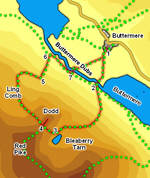
Ascent: 1,850ft
Length: 4 miles
Map: The English Lakes - North Western Area (OS Explorer Map Active)
Last Walked: 28 September 2008
We start in the centre of Buttermere village.
![]() At this point one has a clear choice of routes. Our route takes us onto the minor summit of Dodd, overlooking Buttermere, but if you want to visit the summit of Red Pike instead the route onwards is very obvious, and adds about 400 feet of climb to the walk.
At this point one has a clear choice of routes. Our route takes us onto the minor summit of Dodd, overlooking Buttermere, but if you want to visit the summit of Red Pike instead the route onwards is very obvious, and adds about 400 feet of climb to the walk.
![]() The top of Dodd is marked by two cairns - one on the summit, and one indicating a safe viewpoint over Crummock Water and Buttermere.
The top of Dodd is marked by two cairns - one on the summit, and one indicating a safe viewpoint over Crummock Water and Buttermere.
![]() The start of the route down via Ling Comb is not as obvious as it could be. A clear path does head down into the Comb, but this route soon heads too far to the right. The correct path can be seen further to the left, heading across the comb. To find the start of this path start down the obvious path, but after just over 100 feet look for an indistinct branch heading off down the slope to the left (if you don't find the branch, cut across the heather)
The start of the route down via Ling Comb is not as obvious as it could be. A clear path does head down into the Comb, but this route soon heads too far to the right. The correct path can be seen further to the left, heading across the comb. To find the start of this path start down the obvious path, but after just over 100 feet look for an indistinct branch heading off down the slope to the left (if you don't find the branch, cut across the heather)
This path becomes very clear very quickly, running along the top of what almost looks like a causeway. It then follows the top of a minor ridge that butts out into Ling Comb, heading towards Far Ruddy Beck and Lingcombe Edge. Just before reaching the beck our path reaches a path running across the hillside at a t-junction - turn right and follow this path as it heads down and to the right.
![]() Whichever path you follow eventually comes to the stone wall that separates the open hillside from the trees lining Buttermere. If you have followed the path described here, then you will reach the wall at a point where it climbs up to the right and drops down to the left. Our path passes through the wall, then curves around to the right and after a brief scramble drops down to the top of the trees.
Whichever path you follow eventually comes to the stone wall that separates the open hillside from the trees lining Buttermere. If you have followed the path described here, then you will reach the wall at a point where it climbs up to the right and drops down to the left. Our path passes through the wall, then curves around to the right and after a brief scramble drops down to the top of the trees.
The path through the trees is steep and rocky, needs care and should probably be avoided after wet weather. Follow it all the way down to the valley bottom.