
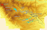
![]() Upper Teesdale is probably the wildest of the North Pennine valleys. The upper reaches of the valley are flanked by the highest of the Pennines Fells - the River Tees rises on the western slopes of Cross Fell, highest of all at 2930 feet. That wildness is reflected in the lack of settlements - west of Middleton-in-Teesdale you will find a few scattered hamlets.
Upper Teesdale is probably the wildest of the North Pennine valleys. The upper reaches of the valley are flanked by the highest of the Pennines Fells - the River Tees rises on the western slopes of Cross Fell, highest of all at 2930 feet. That wildness is reflected in the lack of settlements - west of Middleton-in-Teesdale you will find a few scattered hamlets.
What you will find are waterfalls. Teesdale contained England's highest waterfall at High Force, and the longest cascade at Cauldron Snout as well as many other less well known falls.
![]() The only significant settlement in upper Teesdale is Middleton-in-Teesdale, a welcome sight for walkers on the Pennine Way, which enters Teesdale at Middleton, and then turns west to climb up the dale. What stood out for me on my last visit to Middleton was the number of coffee shops in the town.
The only significant settlement in upper Teesdale is Middleton-in-Teesdale, a welcome sight for walkers on the Pennine Way, which enters Teesdale at Middleton, and then turns west to climb up the dale. What stood out for me on my last visit to Middleton was the number of coffee shops in the town.
![]() Large parts of Teesdale are owned by the Raby estate. The Raby estate is responsible for the distinctive whitewashed barns of Teesdale.
Large parts of Teesdale are owned by the Raby estate. The Raby estate is responsible for the distinctive whitewashed barns of Teesdale.
Lower Teesdale, between Middleton-in-Teesdale and Barnard Castle is less dramatic, but still attractive. The valley opens out here, and the River Tees runs through increasingly gentle farmland. The side valleys of Lunedale and Baldersdale are well worth exploring, with their string of reservoirs running back into the high Pennines.
Teesdale can be found on Ordnance Survey Explorer Maps - EX031 - North Pennines/Teesdale/Weardale