
Introduction
![]() Kirkfell Tarn is actually made up of two sheets of water on the wide summit plateau of Kirk Fell, sitting in the low dip between the eastern and western summits. Both tarns are fairly shallow, with simple grassy banks and wet areas to the north and south.
Kirkfell Tarn is actually made up of two sheets of water on the wide summit plateau of Kirk Fell, sitting in the low dip between the eastern and western summits. Both tarns are fairly shallow, with simple grassy banks and wet areas to the north and south.
![]() The larger of the two is a long, narrow body of water, only slightly lower in level than the ground to the north and south. As a result there are striking views along the tarn towards the nearby fells, and in particular south across Wasdale to Lingmell and Scafell Pike. This is the best feature of these tarns, which are otherwise relatively uninteresting.
The larger of the two is a long, narrow body of water, only slightly lower in level than the ground to the north and south. As a result there are striking views along the tarn towards the nearby fells, and in particular south across Wasdale to Lingmell and Scafell Pike. This is the best feature of these tarns, which are otherwise relatively uninteresting.
Statistics
Grid Reference of centre: NY 197 106
Altitude: 2,470ft
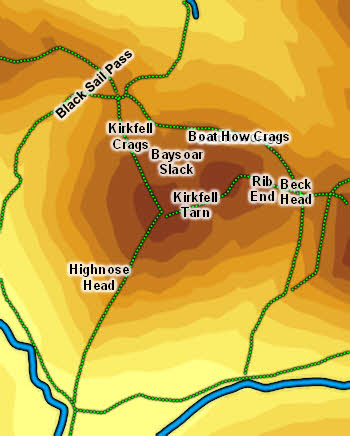
Map
How to Reach
Use any of the routes to the top of Kirk Fell. The easiest comes up Rib End from the col between Kirk Fell and Great Gable. The most direct is the very steep path up the nose of the fell, facing Wasdale Head. The hardest (one I've never attempted) comes up Kirkfell Crags, at the north-western tip of the fell.
Walks
Our ascent of Kirk Fell passes Kirkfell Tarn
Inflows
No becks flow into the tarn.
Outflow
No becks flow out of the tarn either, although becks do form on the slopes of Kirk Fell to the north and south - Ill Gill heading into Wasdale, Sail Beck heading into Ennerdale. Presumably the water from the tarn drains through the fellside into one or the other of these becks.
Other Features
-