
Introduction
![]() Blelham Tarn is a large wedge shaped tarn close to Windermere. It is lined with reed beds and is thus a good home for wildfowl. There is also fishing in the lake, although access is limited to members of the Windermere, Ambleside & District Angling Association. Pike is the main attraction here.
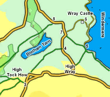
Blelham Tarn is a large wedge shaped tarn close to Windermere. It is lined with reed beds and is thus a good home for wildfowl. There is also fishing in the lake, although access is limited to members of the Windermere, Ambleside & District Angling Association. Pike is the main attraction here.
Blelham Tarn sits in a small valley on the western shores of Windermere. The valley head is close to Outgate, north of Hawkshead, and it runs north-east towards Windermere, before turning north at Low Wray to flow into the lake between Bee Holme and Huyton Hill. The tarn is in the first stretch of the valley, and is overlooked to the south by Latterbarrow
The tarn is owned by the National Trust.
Statistics
Grid Reference of centre: NY 365 004
Altitude: 154ft
Map
How to Reach
Blelham Tarn sits between two paths, neither of which quite reaches the tarn. To the north is a track that run from Outgate to the road north of Wray Castle. To the south is a path that runs from Hole House on the road west of High Wray across to the road south of Wray Castle. Both paths offer good views across the tarn. A permissive path runs past the western edge of the tarn.
Walks
Our walk from Hawkshead to Wray Castle runs alongside both sides of Blelham Tarn.
Inflows
Ford Wood Beck flows into the tarn's south-western end.
A nameless tarn flows into the middle of the north shore.
Wray Beck rises on the eastern slopes of Latterbarrow, runs north through High Wray and then runs into the eastern tip of Blelham Tarn, just to the south of the outflow.
Outflow
Blelham Beck flows north-east out of the beck and then turns north to flow into Windermere. The stretch of the beck nearest to the tarn has been straightened.
Other Features
-