
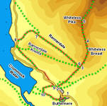
 This walk combines an ascent of Whiteless Pike with a visit to the isolated valley of Rannerdale. Whiteless Pike looms over Buttermere village, and is a fantastic viewpoint, with particularly good views of the fells on the far side of the lakes and a good close-up view of Grasmoor. The path down Rannerdale offers equally good views of the southern face of Grasmoor, and back towards Whiteless Pike.
Ascent: 2,050ft
Length: 5.3 miles
Map: Map: The English Lakes - North Western Area (OS Explorer Map Active) (OS Explorer Map Active)
Last Walked: 26 September 2008
We start at the main car park in Buttermere village. If you are starting from the NT car park to the west, then you will find the turn used in step two just to the south of the car park, and should consider ignoring step 9, as this path is only a few feet from your starting point.
This path climbs up onto Whiteless Breast, and then curves around the hillside to bring us onto the saddle of land between Whiteless Breast and Whiteless Pike. The path to the summit can be clearly seen from here - first heading straight across the flatter area, and then zigzagging all the ![]() way to the summit. From this position one apparent obstacle comes into site - an apparently vertical area of rock that on a busy day causes a serious traffic jam as people reach it and stop. Don't worry - when one finally reaches this apparent obstacle it turns out to be a slab of rock at a shallow angle with any number of easy ways across - most of the delays are caused by people stopping to take pictures!
way to the summit. From this position one apparent obstacle comes into site - an apparently vertical area of rock that on a busy day causes a serious traffic jam as people reach it and stop. Don't worry - when one finally reaches this apparent obstacle it turns out to be a slab of rock at a shallow angle with any number of easy ways across - most of the delays are caused by people stopping to take pictures!
From this point the path climbs up to the summit in a series of easy zigzags. From below the left-hand end of one of the them does appear to be going unnervingly close to the edge of a massive drop, but this is an optical illusion (as became much clearer on the way back down).
The summit of Whiteless Pike offers very good views across to Grasmoor - if you want to visit Grasmoor then the path continues across Whiteless Edge and across the plateau of Wandope to a cross-roads, where the left hand branch leads onto Grasmoor. This walk turns back at this point. After admiring the view, we retrace our steps down Whiteless Pike, past Whiteless Breast, and to the junction of paths we passed at step 3.
![]()
![]()
This path eventually brings us to the road alongside Crummock Water. Unfortunately there isn't a continuous footpath back to Buttermere, but we will only need to use the road in short bursts.
![]() The first burst is very short - turn left onto the road, but then almost immediately leave it to the left and follow the path that climbs across Hause Point. At the top of the climb the path splits, with one branch heading up Rannerside Knotts and the other running south-east across the hillside. Take this second branch, and follow it as it runs back down to the road close to the head of Crummock Water.
The first burst is very short - turn left onto the road, but then almost immediately leave it to the left and follow the path that climbs across Hause Point. At the top of the climb the path splits, with one branch heading up Rannerside Knotts and the other running south-east across the hillside. Take this second branch, and follow it as it runs back down to the road close to the head of Crummock Water.
Our second spell on the road is the longest - we stay on the road for about a fifth of a mile, past the entrance to Wood House. Just past this gateway, the road turns sharply to the right and enters some woods - at this point leave the current road to the left and follow what appears to be the original route of the road.