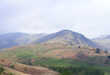
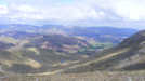
 This fine walk takes us up to Swirl How, at the geographical hub of the Coniston Fells, along the ridge that overlooks Wrynose Pass from the south. This route provides ever-improving views north towards Crinkle Crags and the Scafell group, while the Old Man of Coniston comes into sight as we reach Great Carrs.
Ascent: 2,670ft
Length: 8.5 miles
Maps: The English Lakes - South Western Area (OS Explorer Map Active) and The English Lakes - South Eastern Area (OS Explorer Map Active)
Last Walked: April 2009
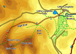
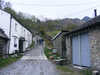
We start at the telephone box in the hamlet of Little Langdale. There is limited roadside parking in Little Langdale, some by the telephone box and some to the east of the pub.
1: NY 315 033
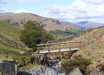
The telephone box sits opposite a very minor road signposted for Tilberthwaite. Follow this road past two houses, and then turn right through a kissing gate onto a public footpath that cuts across the fields and brings us to Slater Bridge, which takes us across the River Brathey.
2: NY 311 029
After crossing the bridge our path brings us up to a track that runs west to east along the base of the fells. Turn right onto this track, and follow it as it runs west up the valley, with views of Little Langdale Tarn to the right. Our track turns sharply left as it passes Low Hall Garth (now a climbing hut), then turns right, passes another isolated building, and finally emerges from between its stone walls onto the open fellside.
3: NY 305 028

Just after we emerge onto the open fellside a second track joins ours from the back left. Ignore this and continue on for a short distance, until our track splits in two. Take the left-hand branch, which climbs up over the flank of the fell and heads into the valley of Greenburn.
4: NY 295 023
We follow this track for three quarters of a mile, as it approaches the entrance to Greenburn, with Birk Fell on the left and Hollin Crag on the right. Just after we draw level with the first crags on the ridge to the right our track passes through a wall. Just past the wall a path leaves to the right
- turn onto this path, cross the Greenburn Beck on a footbridge supported by a massive tree trunk, and follow the path as it climb steeply up onto our ridge. From here onwards our route is obvious - follow the path as it climbs up the ridge, curving gently to the left as it goes. Our initial steep climb is followed by a level glassy stretch, then a short minor scramble and a long gently climb.
5: NY 269 013
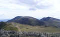
The tops of Little Carrs and Great Carrs are covered with a boulder field. The right of way runs through these boulders, but this difficult section can be bypassed. When the path first enters the boulders, leave it to the right, and follow the edge of the boulders, climbing gently all the time. The boulder field dies out just before the summit of Great Carrs, so our route brings us up to the summit from behind.
 From here the route on to Swirl How is obvious - a wide path running around the top of Broad Slack and curving around to the left to reach the cairn on top of Swirl How. Take time to visit the memorial to the crew of a Halifax bomber than can be found just down from the summit of Great Carrs.
6: NY 272 005
To return to Little Langdale we simply retrace our steps down over Great Carrs, Little Carrs and back down the ridge into Greenburn.
