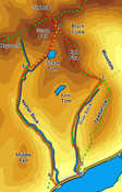
 This walk takes us into two of the less well known valleys hidden on the northern side of Wast Water, bringing us onto the ridge that leads to Red Pike and Scoat Fell, before returning via Scoat Tarn and the dramatic but often quiet valley of Nether Beck.
Ascent: 3,000ft
Length: 8 miles
Maps: The English Lakes - North Western Area (OS Explorer Map Active)  and Map: The English Lakes - South Western Area (OS Explorer Map Active)
Last Walked:
We start from the small car park at Overbeck Bridge, on the northern shore of Wast Water.
1: NY 167 068
Follow the path that runs north from the car park, with the beck to the left. This path soon starts to climb up the flanks of
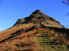
Yewbarrow, before reaching the wall that runs straight up the southern ridge of the fell. Cross the wall, and then follow it up towards the crags.
2: NY
167 071
Just below the crags a stile crosses the wall. At this point our path turns away to the left, leaving the wall to head up the valley. After a short distance the path splits in two - the right-hand branch
heads up onto Yewbarrow, while the left-hand branch heads up the valley, with the crags of Yewbarrow to the right and the slope down to Over Beck to the left. We take this left-hand branch and follow it as it climbs up the valley.
3: NY 174 095
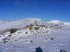
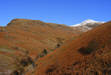
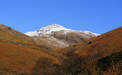
This path eventually bring us to Dore Head, and the first views down into Mosedale. Turn left here and follow the very clear path that climbs up and over Red Pike. Towards the top of the pike the main path runs some way below the summit, so pick a suitable moment to break away to the right to visit the cairn, which sits on the very edge of the precipice. After that continue on north down to the gap between Red Pike and Scoat Fell.
4: NY 162 110
Several footpaths are shown meeting at or close to this dip, but only two are really clear on the path - the one back up Red Pike, and the one that curves away to the right heading for Pillar. Neither of these are our path!
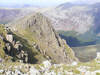 If you want to visit the summit of Scoat Fell and Steeple (highly recommended), then head directly up the slope ahead (to the left of the Pillar path). This is an easy slope, mostly grassy with some rocky outcrops, and eventually brings us to the stone wall that runs along the summit of the fell. Cross this wall and turn left to reach Pillar, which sits out in space overlooking Ennerdale. After visiting Scoat Fell and Steeple retrace your steeps back down to the dip.
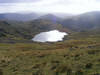 Our route on heads south-west down the slope towards Scoat Tarn (left turn if coming from Red Pike, right if from Scoat Fell). The upper part of the path is clear in places, although tends to disappear from time to time - on these occasions keep on heading down hill, aiming for the right bank of the tarn. By the time we reach Scoat Tarn the path is clear, and remains clear all the way to Nether Beck.
5: NY 151 098
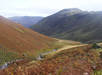
Our path crosses Nether Beck and reaches a T-junction. Turn left at this point and follow the path that runs alongside Nether Beck almost all the way back to the road.
6: NY 159 068
About a quarter of a mile short of the road the path begins to curve away to the right, heading away from the beck. At this point look out for a path that branches off to the left, following the beck down to the road. Turn left onto the road and follow it back to our starting point (after very wet weather this area might be a bit boggy, so it may be worth sticking to the main path, which joins the road about a quater of a mile further west).
