
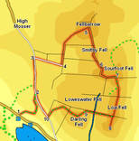
 This walk visits five separate summits on the Loweswater Fells - Fellbarrow, which gives us impressive sweeping views towards Scotland and east to Skiddaw, the intermediate summits of Smith Fell and Sourfoot Fell and the southern summits of Low Fell and Darling Fell, two amazing viewpoints overlooking Loweswater and Crummockwater, and with more distance views of Buttermere and the high fells around Great Gable.
Although the Loweswater Fells are quite gentle this walk visits most of the many summits, and involves quite a bit of climbing, and some surprisingly steep slopes.
Unusually for the Lake District the top of these fells are crossed by a network of well maintained fences, which our map shows as thin black lines.
Ascent: 1,700ft
Length: 5 miles
Map: The English Lakes - North Western Area (OS Explorer Map Active)
Last Walked: February 2010
We start from the road side car park close to the phone box at the western end of Loweswater.
At the end of the track stiles lead into the field to the left or straight ahead. Take the stile to the left, and head along the right-hand side of this field, heading towards the southern slopes of Fellbarrow.
This brings us towards the only awkward moment on the walk - about two-thirds of the way across this field a stile crosses the fence to the right. Paths then continue up along both sides of the fence, but neither lead to an easy way onto the summit.
I stayed on the left, which brings us to a blocked gate at the far end of the field - fortunately the fence here isn't very high, so I was able to cross over the fence and continue up the hill. Once over this barrier keep climbing up alongside the fence, now running to our right. Eventually the fence turns to the right and runs away across the hill side. At this point aim for the skyline and keep climbing until you reach the summit of Fellbarrow (beware of many false summits).
If you don't want to risk a fence crossing, then cross the stile two-thirds of the way across the first field. Climb up the same slope, but on the opposite side of the fell. At the corner of this field turn right and follow the fence across the hillside to the far corner of the field. Cross a stile to the left and climb up to the summit of Fellbarrow.
![]() A fence runs from north to south along the summit of Fellbarrow, with the OS trig point on the western side. It is well worth crossing this fence (easy at this point) to visit the eastern side of the summit, a great viewpoint for the Vale of Lorton, but our route onwards follows the western side of the fence - from the trig point face the fence, then turn right and follow the fence as it runs down the southern slopes of Fellbarrow.
A fence runs from north to south along the summit of Fellbarrow, with the OS trig point on the western side. It is well worth crossing this fence (easy at this point) to visit the eastern side of the summit, a great viewpoint for the Vale of Lorton, but our route onwards follows the western side of the fence - from the trig point face the fence, then turn right and follow the fence as it runs down the southern slopes of Fellbarrow.
A stile takes us across a fence at the bottom of this slope. We then follow the path onto and over the summit of Smithy Fell, crossing a second fence on the far side of the summit.
![]() From the summit head back north along the ridge to reach a fence that runs across a slight dip in the ridge. Turn left and follow this fence down into the valley between Low Fell and Darling Fell - from above this path looks like
From the summit head back north along the ridge to reach a fence that runs across a slight dip in the ridge. Turn left and follow this fence down into the valley between Low Fell and Darling Fell - from above this path looks like ![]() itmight become very steep, but this is largely an optical illusion, and it remains reasonable all the way down to Crabtree Beck.
itmight become very steep, but this is largely an optical illusion, and it remains reasonable all the way down to Crabtree Beck.
Cross the beck and follow the path as it follows the fence up the steep slopes of Darling Fell. Just before reaching the skyline the path leaves the fence and heads left to reach the summit.