
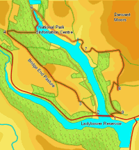
 This walk takes us around the northern branch of the gigantic Ladybower Reservoir, exploring the hills around this part of the upper Derwent valley. We start by climbing up onto Bridge-end Pasture, a grassy hilltop that provides a most unusual view west towards Kinder and Bleaklow. We then drop down to the reservoir, and visit the information centre at its normal tip, before climbing back onto the flanks of the Derwent Moors, where we find a series of excellent viewpoints overlooking Ladybower.
Ascent: 1,500ft/ 470m
Length: 7.8 miles/ 12.6km
Map: Explorer 01 Dark Peak Area
Last Walked: 8 June 2007
There is roadside parking on the main A 57 as it runs alongside the reservoir, just to the east of the bridge across the northern spur of the lake, at Ashopton. There is also a car park to the west of that bridge, but sadly there is no path along the roadside, so this is not an ideal place to start. Only use it if the roadside parking is full.
![]() Turn right onto the side road that heads north, along the left hand side of the northern spur of the lake. After a short distance, turn onto a footpath that leaves the road to the left (a short flight of steps leads up to a gate, with a National Trust signpost just beyond). This path climbs straight up the right hand side of the first field, then cuts diagonally to the right across the second, heading for the north west corner.
Turn right onto the side road that heads north, along the left hand side of the northern spur of the lake. After a short distance, turn onto a footpath that leaves the road to the left (a short flight of steps leads up to a gate, with a National Trust signpost just beyond). This path climbs straight up the right hand side of the first field, then cuts diagonally to the right across the second, heading for the north west corner.
Here a gate leads into a third field, with a clear path that continues to the north west, before reaching a gate just south of the northern edge of the field, leading into a fourth field. Here the path has been diverted to avoid Crookhill Farm. At the entrance to this fourth field, turn sharply to the right, heading for a gap in the northern wall of the field. This leads into a fifth field. Here we turn slightly to the left, and head diagonally across the field, heading just to the right of a barn that is the most northerly building of Crookhill Farm.
![]() As we pass that barn, we reach the road that leads to Crookhill Farm. Cross straight over this road into the next field. Here a footpath leads across the southern edge of the field, with some woods to the left, and the field to the left. At the western edge of this field, we reach a small patch of National Trust land, surrounding the crags of Crook Hill.
As we pass that barn, we reach the road that leads to Crookhill Farm. Cross straight over this road into the next field. Here a footpath leads across the southern edge of the field, with some woods to the left, and the field to the left. At the western edge of this field, we reach a small patch of National Trust land, surrounding the crags of Crook Hill.
![]() Just inside the NT land, we reach a track. Turn right, and follow this track north to the edge of the NT land. Here we enter a large, oddly shaped field (the third in this stage), crossed by a number of tracks. Our aim is to reach the north western corner of the field. We achieve this by following the main track. For the first 300 feet it runs to the left of a stone wall. At the end of this wall, the track swings away to the left. We continue along this section of the track for a quarter of a mile, always gently climbing, before the track splits (ignore any other earlier branches
Just inside the NT land, we reach a track. Turn right, and follow this track north to the edge of the NT land. Here we enter a large, oddly shaped field (the third in this stage), crossed by a number of tracks. Our aim is to reach the north western corner of the field. We achieve this by following the main track. For the first 300 feet it runs to the left of a stone wall. At the end of this wall, the track swings away to the left. We continue along this section of the track for a quarter of a mile, always gently climbing, before the track splits (ignore any other earlier branches ![]() that head away to the right). Our eventual target is the grassy ridge of Bridge-end Pasture - for the moment our track aims just to the left of this ridge. At the split in the track take the branch that leaves to the right, still heading uphill, towards the north western corner of the field.
that head away to the right). Our eventual target is the grassy ridge of Bridge-end Pasture - for the moment our track aims just to the left of this ridge. At the split in the track take the branch that leaves to the right, still heading uphill, towards the north western corner of the field.
Here a gate leads into the south eastern corner of the next (fourth) field. Here the route is obvious, heading directly across the field, climbing up towards the highest part of the ridge. In the next (fifth) field we finally reach the highest point of the ridge, with fantastic views west towards Kinder Scout and Bleaklow.
![]() We can also see north west towards the next stage of our walk. Continue across this field, along the top of the ridge. In the next field we reach the edge of the woods that surround Ladybower Reservoir. Here a track leads along the top of the ridge, with fields to the left and the woods to the right. We follow this track all the way to the north western corner of the woods, ignoring the track that heads down into the woods about a third of a mile after we first reach the trees).
We can also see north west towards the next stage of our walk. Continue across this field, along the top of the ridge. In the next field we reach the edge of the woods that surround Ladybower Reservoir. Here a track leads along the top of the ridge, with fields to the left and the woods to the right. We follow this track all the way to the north western corner of the woods, ignoring the track that heads down into the woods about a third of a mile after we first reach the trees).
We reach the lake side road just to the south of a information centre, hidden in the trees at the northern tip of the lake. Turn right onto the lakeside road, and then almost immediately turn right onto a path that heads down towards the lake shire itself, before turning left into the trees and climbing up to the road into the car park. Turn right onto this road, and follow it to the information centre.
Leave the information centre car park on a path that passes to the right of the building, following the lake shore to its northern tip. The path then runs alongside the Derwent for a short distance, before reaching a minor road.
![]() Turn right onto this road, and follow it as it crosses over the Derwent. It then runs across a small patch of open ground in front of the Derwent Dam, before turning through almost 180 degrees to the right, and heading down the eastern side of Ladybower Reservoir. Follow this road south as it passes a series of isolated farms.
Turn right onto this road, and follow it as it crosses over the Derwent. It then runs across a small patch of open ground in front of the Derwent Dam, before turning through almost 180 degrees to the right, and heading down the eastern side of Ladybower Reservoir. Follow this road south as it passes a series of isolated farms.
We stay on this road for the next mile and a quarter, eventually leaving it on a path that climbs up the hillside to the left (if at this stage you want a less strenuous end to the walk, ignore this junction and follow the lakeside road all the way back to the starting point). For the first mile or so the road runs almost straight, curving gently to the left. Just before we reach our path, the road kinks sharply left, then right to pass around a small bay in the lake shore. We follow the road south for about a fifth of a mile beyond this point. Finally, we reach a point where a private drive joins the road from behind and to the left. At the same point a footpath leaves the road, climbing up and to the right along a line of flagstones.
![]() This path is going to take us up to the very edge of the Derwent Moors. The first stage of the path takes us across this first field, climbing gently as first as it curves to the left, but then climbing more steeply directly up the side of the hill, before reaching a small cluster of buildings. The path passes between these buildings, and then turns to the right. It then runs across the hillside for a short spell, before
This path is going to take us up to the very edge of the Derwent Moors. The first stage of the path takes us across this first field, climbing gently as first as it curves to the left, but then climbing more steeply directly up the side of the hill, before reaching a small cluster of buildings. The path passes between these buildings, and then turns to the right. It then runs across the hillside for a short spell, before ![]() reaching the tip of a small path of woodland. Here we follow the path as it climbs more steeply to the left of these trees.
reaching the tip of a small path of woodland. Here we follow the path as it climbs more steeply to the left of these trees.
At the opposite end of the trees, the path reaches the edge of the moorland, and continues to climb diagonally across this next field, heading towards a wall that runs across the hillside. We pass through this wall, and then turn right onto a track that runs across the hillside, with the path just to the right and the open moors to the left.
![]() We follow this path all the way around the valley of Grainfoot Clough, curving to the right all the way to the rocky outcroppings at Whinstone Lee Tor. The path then curves around to the left, passing below these crags, before reaching a point where six paths join. We will be returning to this junction later, but for the moment we are going to take a diversion onto Lead Hill, a superb viewpoint overlooking Ladybower.
We follow this path all the way around the valley of Grainfoot Clough, curving to the right all the way to the rocky outcroppings at Whinstone Lee Tor. The path then curves around to the left, passing below these crags, before reaching a point where six paths join. We will be returning to this junction later, but for the moment we are going to take a diversion onto Lead Hill, a superb viewpoint overlooking Ladybower.
![]() Of these six paths, the first to the right leads down a steep gully, towards the lake. This will be our eventual route onwards. The next path runs almost due west, leading to a small path of bare ground. The third path heads south west, across a patch of level ground. Take this third path, and follow it for around 800 ft. At this point we reach a small cluster of boulders just to the right of the path, which marks our viewpoint.
Of these six paths, the first to the right leads down a steep gully, towards the lake. This will be our eventual route onwards. The next path runs almost due west, leading to a small path of bare ground. The third path heads south west, across a patch of level ground. Take this third path, and follow it for around 800 ft. At this point we reach a small cluster of boulders just to the right of the path, which marks our viewpoint.
To continue on return north to the junction of the six paths. This time take the left hand path heading west down the steep gully. At the bottom of this gully, follow the path as it curves around to the left, and then as it passes through a large gap in some woods.