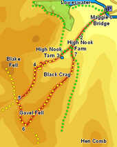
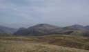
 This walk takes us up one of the Lake District's less frequented fells, Gavel Fell in the heart of the Loweswater Fells. This fell presents a rather uninteresting grassy face to Ennerdale, but on the Loweswater side it can boast one of the quieter tarns, a sizable crag and a super summit ridge running north-east from the highest point of the fell towards a great viewpoint at the top of Black Crag overlooking High Nook tarn.
Ascent: 1,400ft
Length: 5 miles
Map: The English Lakes - North Western Area (OS Explorer Map Active)
Last Walked: Spring 2011
We start from the small National Trust car park at Maggie's Bridge, just off the main road at the eastern end of Loweswater lake.
1: NY 134 210
Turn left out of the Maggie's Bridge car park (back along the road) then almost immediately turn right, onto a lane that leads towards High Nook Farm.
2: NY 128 205
Follow this track as it runs through High Nook Farm, then as it climbs up quite steeply, with Highnook Beck running through a steep-sided valley to the right. This track runs up into the valley between
Carling Knott and Black Crag, before fading away (ignore the track that climbs away to the left just after we pass through a stone wall). The path then splits in two - take the left-hand branch, which heads up a gentle grassy slope to
High Nook Tarn.
3: NY 124 199
At the tarn the path turns a little to the right, running along the right-hand side of the tarn, passing over some stepping stones at the water's edge. Follow this path as it runs towards the head of the valley, a tongue of land that rises up between Highnook Beck on the left and an un-named beck on the right.
4: NY 118 196
A clear path climbs up the valley head, zig-zagging up the slope. About half way up the slope the path does become a little unclear, but just continue on up the slope until a very clear path re-appears, now running up a very clear groove in the hillside. This sizable groove also zig-zags a little, before heading left across the slope, climbing up to Fothergill Head.
5: NY 114 190
A fence runs across the top of the pass between
Blake Fell and Gavel Fell. Our path crosses the fence, and then continues on down the opposite side of the pass towards Croasdale, but just past the fence a second path branches off at ninety degrees to the left. Follow this path as it runs up to the summit of Gavel Fell, running to the right of the fence.
6: NY 116 184
The summit of Gavel Fell runs from north-west to south-east, with the highest point at the north-western end. A long ridge runs north-east from the summit, heading towards the top of Black Crag. Close to the highest point of the fell a second fence runs north-east, passing just to the right of the north-east ridge. A stile crosses the main fence just to the left of this second fence. Cross this stile, and follow the clear path that runs north-east, running over a secondary summit about half-way along the ridge. The path then continues on along the ridge, before curving away to the right to run around the top of Black Crag, and along a heather-covered ridge before eventually dropping down to reach a track.
7: NY 127 198
Turn left onto this track, which turns out to be the one we ignored back at step two. This brings us back onto the track that runs through High Nook Farm, so turn right onto this track and follow it through the farm and back to Maggie's Bridge.
