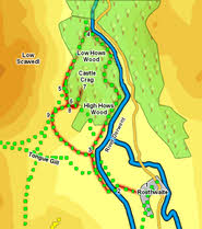
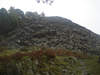
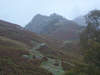
 This is our second ascent of Castle Crag, this time combined with a complete circuit of the crag, taking us through the quarries on its eastern slopes. Despite its modest height Castle Crag is a splendid viewpoint, with contrasting views - north towards Derwent Water, Skiddaw and Keswick and south into the heart of Borrowdale.
Ascent: 820ft
Length: 3.5 miles
Map: 
Last Walked: March 2012
We start from the National Trust car park in Rosthwaite.
1: NY 257 148
Turn right out of the NT car park and follow the lane as it runs through the village and all the way to the River Derwent.
2: NY 253 148
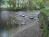
There are two ways across the river. If water levels are right it is possible to cross over the stepping stones where the track first reaches the water. If not follow the track along the river and cross over the stone bridge. In either case turn right and follow the path as it runs along the opposite side of the river, with the water to the right.
3: NY 251 150
These two routes merge at the stone bridge. Continue along the riverside path, which we are now going to follow for some distance. The river itself is left twice - the first time soon after the bridge, the second and longer time soon after it enters the forest that coats most of Castle Crag. On this stretch of the path we pass through a large abandoned quarry which has now almost disappeared into the trees. Just past the quarry the path passes through a stone wall.
The main route turns right and drops down to the river then turns left and follows the river to Gowder Dub and its junction with Broadslack Gill (there is also a path that turns left and follows the wall - this looks as if it should cut off quite a corner, but the ground is difficult, the route blocked by felled trees and there is an awkward fence to cross at the end, so stick to the real path).
4: NY 250 165
The riverside path brings us to Broadslack Gill, where the Derwent turns to the right and Broadslack Gill joins it from the valley between Castle Crag and the slopes of High Spy. Turn left onto the path that runs alongside Broadslack Gill. This path climbs up an increasingly dramatic valley between the two slopes, with massive crags dominating on the left and steep rocky slopes on the left.
5: NY 247 158
As this path approaches the top of the pass the crags to the left end and the valley opens out a little. Look out for a path that branches off to the left. Follow this path, which then curves around further left, passes a bench and climbs up towards a stile that crosses a stone wall.
6: NY 248 158
After crossing the stile turn right and follow the path that runs alongside the stone wall. As we head towards the corner of this field (marked by two stiles), a large cairn comes into sight on the left. A path leads to this cairn from the field corner. The cairn marks the start of an unusual path built into a scree slope created by the quarry on top of the fell. Follow this path as it zig-zags up the front of the scree slope.
7: NY 249 159
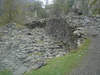
This brings us almost to the top, but not quite. We are now at the entrance to the quarry (which is well worth a visit), but to reach the top look for a path that climbs up the spur of ground to the right of the quarry itself. This path climbs up for a short distance, then runs around the top of the quarry to reach the summit itself. After visiting the summit retrace your steps down to the quarry and then back down the zig-zag path.
8: NY 248 157
From the cairn at the foot of the scree head towards the corner of the field with its two stiles. Cross over the right-hand stile, then immediately cross a stile over a fence to the right and follow the path as it runs alongside this fence. This path heads towards another crag, but just before reaching it runs down an unexpected slope to bring us back to the path we left back at step 5.
9: NY 246 156
Turn left onto this path and follow it to the top of the pass. Continue on for a short distance until you reach a minor path that heads towards a gate in the wall to the left. After passing through this gate follow the clear footpath that curves its way down the slope. This eventually brings us down to the River Derwent, just short of the stone bridge - turn right, cross the river by either the bridge or stepping stones and return to our starting point.
