
 Ben Nevis is the highest mountain in the British Isles, and probably the most often climbed (at least it was on the day I went up!). On a clear day the views from the top are absolutely spectacular, with mountains disappearing into the distance in every direction.
This will not be one of our normal walk descriptions, based on instructions for follow the route. The tourist path up Ben Nevis is so clear, and so busy, that it is impossible to miss it, even in poor visibility (although snow cover may make things more difficult). Instead we will focus on describing the nature of the path as it climbs up the flanks of this most impressive mountain.
Most guide books will tell you that the tourist path isn't the best way up the mountain, but for me it has several big advantages. The first is that you don't need a good head of heights to use it - other routes either cross narrow ridges or come up very steep slopes. Second, it is very easy to follow.
Although the route is easy the climb isn't, so make sure you've allowed for a long full day, and take plenty of water - the upper reaches are entirely dry.
Ascent: 4,400ft
Length: 11 miles
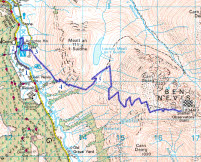
Map:
Last Walked: July 2009
We start from the Ben Nevis visitor centre in Glen Nevis
Cross the wall at the far end of the field. On the far side of the wall cross a track and follow our path for a little longer until it joins a path that runs from right to left across the mountain, climbing as it goes. Turn right onto this path. This marks the true start of the ascent of Ben Nevis - from here on it its uphill all the way!
![]() This path runs around the western and southern flanks of Meall an t-Suidhe, climbing as it goes. For most of the time the path runs anti-clockwise around the hillside, but there are a couple of zig-zags on the way. This is quite a good path although sometimes a little rough underfoot.
This path runs around the western and southern flanks of Meall an t-Suidhe, climbing as it goes. For most of the time the path runs anti-clockwise around the hillside, but there are a couple of zig-zags on the way. This is quite a good path although sometimes a little rough underfoot.
![]() Towards the head of this valley the path turns sharply back and to the left to make one more massive zig-zag, before turning back to the right. The path then climbs up past Lochan Meall an t-Suidhe (on the left), before joining another path and turning right.
Towards the head of this valley the path turns sharply back and to the left to make one more massive zig-zag, before turning back to the right. The path then climbs up past Lochan Meall an t-Suidhe (on the left), before joining another path and turning right.
This finally brings us onto the slopes of Ben Nevis itself. The path zig-zags most of the way to the top, eventaully straightening out as it reaches the upper ridge. This is a dramatic rocky wilderness. When we climbed Ben Nevis in July there was even a large patch of snow close to the summit! I would recommend ignoring the fell runner's route, which ignores the zig-zags and heads straight up the flank of the mountain - it may be shorter in distance, but those of our party who used it found it much slower going underfoot. The main path is very well built (and was being improved almost under our feet!).
After the long series of zig-zags the path eventually levels out somewhat. There is one more steep climb and then the summit comes into view, crowded with a surprisingly large number of constructions.
![]()
![]()
![]()
![]()